

Ground-penetrating radar (GPR) is a geophysical technology that uses radar pulses to visualize and map subsurface features. It allows for non-destructive investigation of what lies beneath the ground’s surface, making it an invaluable tool in various industries, including construction, archaeology, law enforcement, and geology. This article will delve deeper into GPR technology, explore its uses and benefits, and more.
How Do You Define GPR?
GPR is a geophysical technology used to image and map subsurface structures and features. It transmits radio frequency (RF) pulses into the ground and analyzes the signals that bounce back. By measuring the amount of time, in nanoseconds, it takes for the signals to return in addition to the intensity of the reflections, radar can provide a detailed image of where potential targets lie beneath the surface.
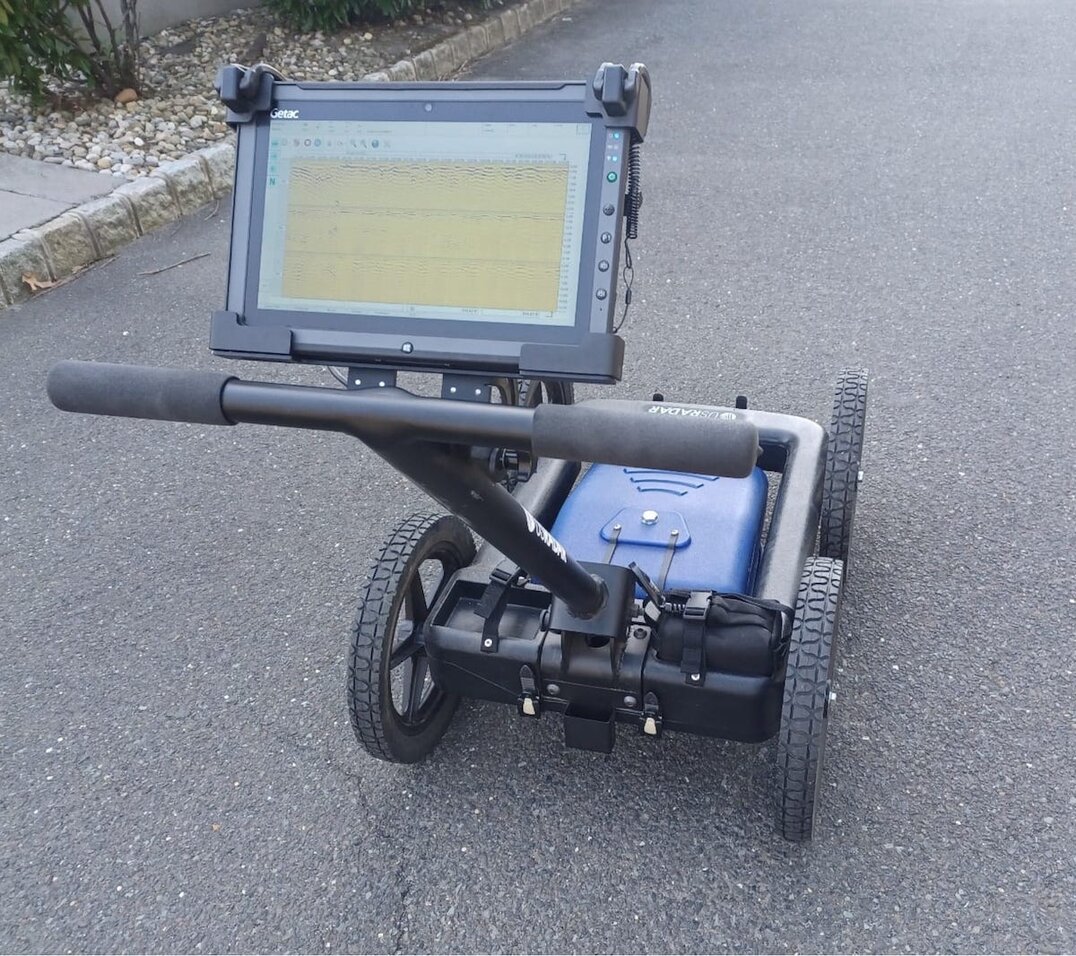
These systems have multiple components, including a control unit, antennas, and a display screen. The antennas emit and receive radar signals, while the control unit processes the data and displays it in real-time on the screen.
Overall, ground-penetrating radar is a versatile and powerful tool that has revolutionized how we explore and understand the subsurface. Its non-destructive nature and ability to provide detailed imaging make it an invaluable asset in various fields, contributing to advancements in archaeology, geology, civil engineering, and environmental studies.
How Does GPR Work?
How does GPR work? GPR operates on electromagnetic wave propagation and reflection principles. It provides valuable insights into the subsurface by emitting radar pulses into the ground and analyzing the signals that bounce back and are read by the processing software.
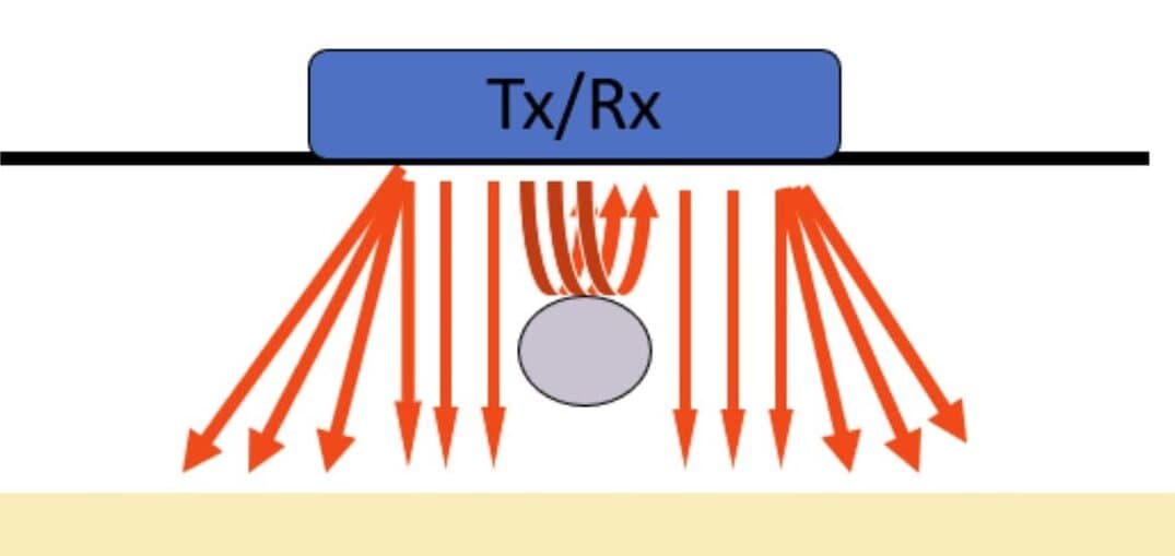
Radar pulses are emitted into the ground and encounter various materials with different electromagnetic properties. These materials can include changes in density, moisture content, and composition, affecting how the radar waves interact with them.
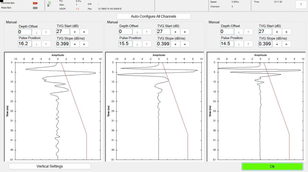
The reflected signals from the subsurface features travel back to the system’s antennas, where they are received and recorded. These signals contain valuable information about the subsurface structure. By analyzing the characteristics of these signals, such as their amplitude and travel time, GPR can create a detailed subsurface image.
With the ability to penetrate various materials, ground-penetrating radar has become an invaluable tool in a dynamic range of applications. It is used in archaeology to discover hidden artifacts and ancient structures, in geology to study underground formations, in civil engineering to locate utilities and assess infrastructure condition, and in environmental studies to investigate soil composition and contamination.
By using the power of electromagnetic waves and advanced signal processing techniques, GPR continues to push the boundaries of subsurface exploration. Its ability to provide detailed and non-destructive information about the subsurface makes it an essential tool in numerous industries, contributing to our understanding of the world beneath our feet.
What is GPR Used For?
Ground-penetrating radar uses radar pulses to image the subsurface. It has various applications across a dynamic range of industries, making it a versatile tool for exploration and analysis.
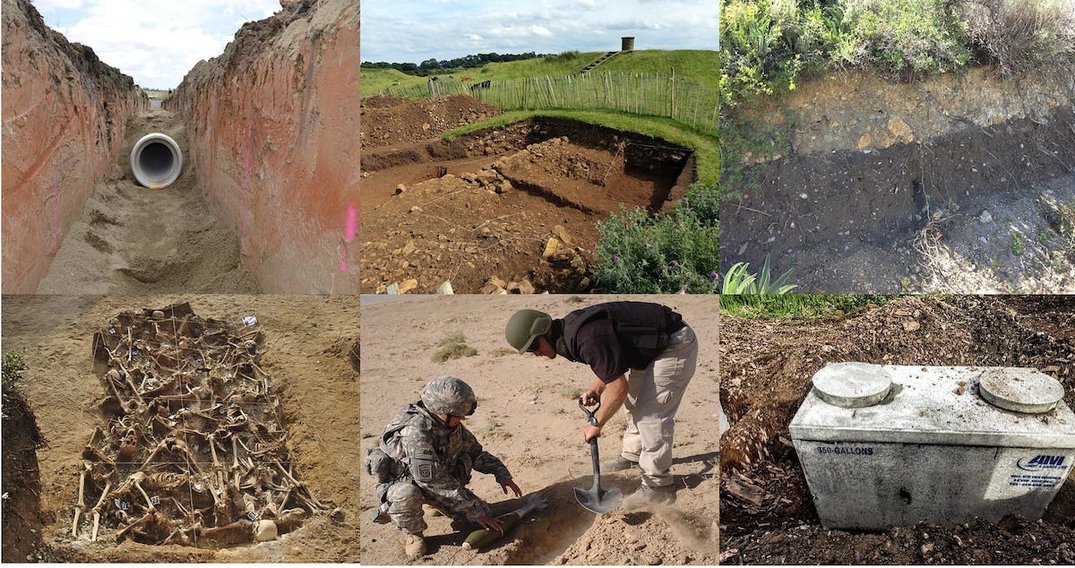
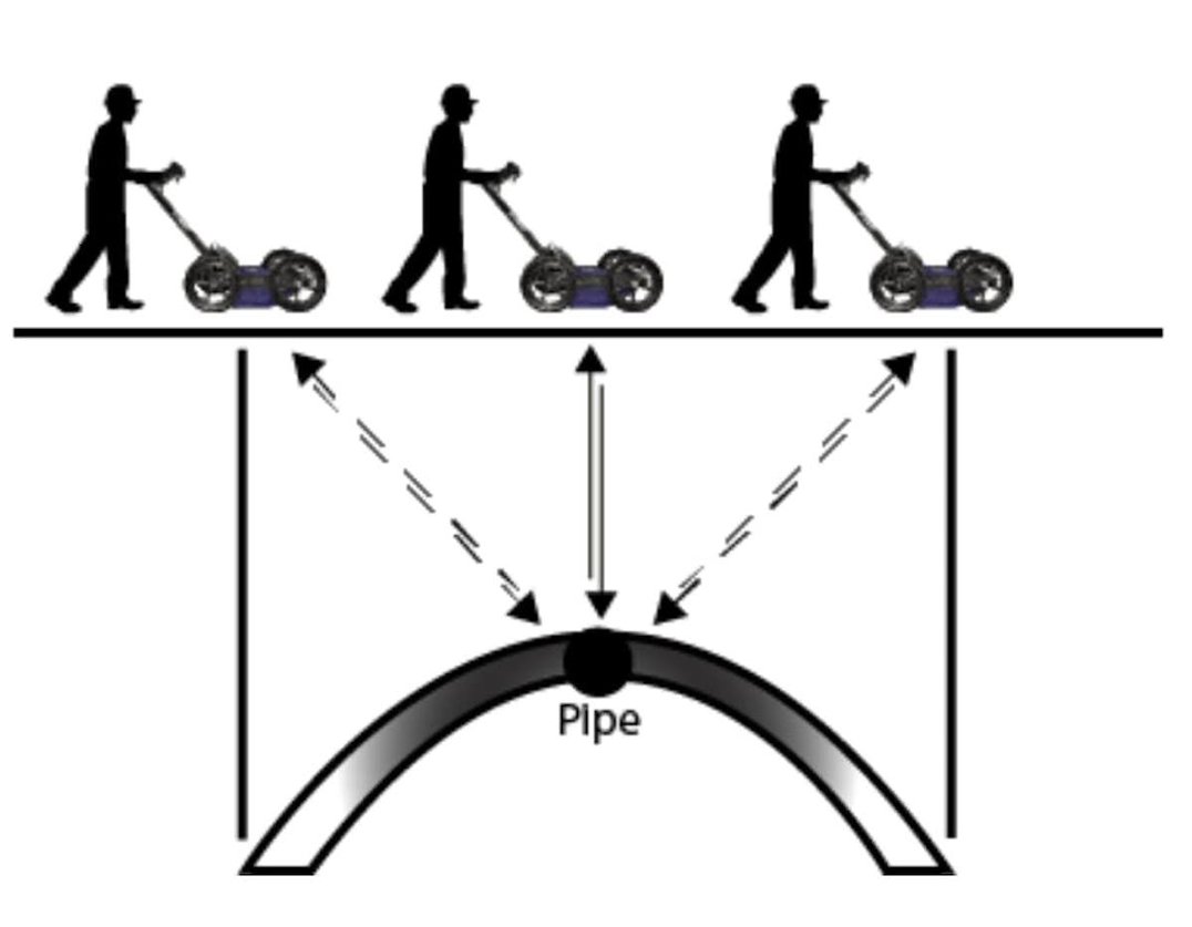
In construction and engineering this technology is commonly used for locating utilities, such as pipes and cables, before excavation or drilling. By using these systems, construction teams can accurately recognize the location of these underground assets, reducing the risk of accidental damage and ensuring the project’s safety. Additionally, GPR can spot voids, such as underground cavities or sinkholes, which could threaten construction projects. This information allows engineers to make informed decisions and take necessary precautions to ensure the stability of the structures being built.
Archaeology is another field where GPR proves to be invaluable. Traditional archaeological investigations often involve extensive excavation, which can be time-consuming, expensive, and ultimately destructive. However, with GPR archaeologists can distinguish buried structures, artifacts, and even ancient burial sites without requiring extensive digging. By sending radar pulses into the ground and analyzing the reflected signals, this technology can create subsurface images, providing archaeologists with a non-invasive method to explore and study the past.
Geology and environmental studies also benefit significantly from the use of GPR. It can help geologists understand the stratigraphy and structure of the Earth’s subsurface by displaying subsurface geological formations. This information is crucial for various applications, such as mineral exploration, groundwater mapping, and geological hazard assessment. GPRs can also aid in identifying the stability of slopes and foundations, providing valuable insights for engineering projects in geologically complex areas.
This technology has revolutionized how we explore and understand the subsurface, from construction to engineering to archaeology and geology. With its versatility and non-destructive nature, ground-penetrating radar continues to find new applications in various industries. Law enforcement departments around the globe use GPR for forensic investigations. Soldiers in various countries are locating IEDs and other unexploded ordinances. Surveys from locating septic tanks to mapping tree roots have GPRs being used as a project tool.
What Are the Benefits of GPR?
GPR offers several advantages over traditional subsurface investigation methods:
Non-Destructive Techniques
One GPR benefit is its non-destructive technique. This means that it allows for non-invasive examination of the subsurface, minimizing the need for costly and time-consuming destructive excavation. In the past, when subsurface investigations were required, excavation was often the only option. This caused disruption and damage to the surrounding area and added significant expenses to the project. With this technology, however, the need for excavation is significantly reduced, resulting in cost savings and a more efficient investigation process.
Quick Data Collection
Another benefit of GPR is its ability to collect data rapidly. With advancements in this technology, data can be collected quickly and analyzed in real-time. As the equipment scans the subsurface, the data is immediately processed and displayed, providing immediate results. This real-time analysis allows for on-site decision-making, saving time and enabling prompt action if any anomalies or potential hazards are detected.
High-Resolution Imaging
Furthermore, GPR provides high-resolution images of subsurface features. The radar pulses the equipment, penetrates the ground, and bounces back when encountering materials or structures beneath the surface. These reflections are then recorded and processed to create detailed images.
The high resolution of ground-penetrating radar allows for accurate interpretation of the data, enabling the identification of various subsurface features such as utilities, voids, buried structures, and geological formations. This level of detail is crucial in many applications, including archaeological surveys, utility mapping, and geological investigations.
Portability and Adaptability
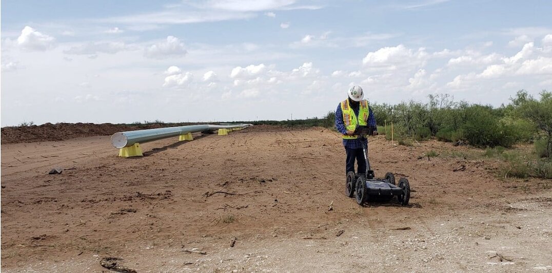
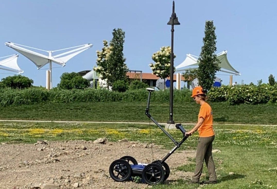
Lastly, this equipment is portable and adaptable. Whether it’s a construction site, a historical site, or a remote area, GPR can be easily transported and deployed. This portability allows for efficient data collection in diverse locations, making ground-penetrating radar a versatile tool for subsurface investigations. When combined with other technology, such as GPS, GPR can become an even more useful tool. Highly accurate maps of the subsurface prevent crippling utility strikes that cost millions of dollars to repair. These maps can be created with a few taps on a tablet screen. Maps can also be imported as a “sanity check” when surveying in a potentially troublesome soil composition.
In conclusion, this technology offers numerous benefits over traditional subsurface investigation methods. Its non-destructive nature, rapid data collection, high resolution, and portability make it an invaluable tool in various industries. With radar, projects can be executed more efficiently, costs can be reduced, and valuable insights can be gained from the subsurface without requiring extensive excavation.
How Deep Can GPR Penetrate?
The penetration depth of GPR depends on several factors, including the frequency of the radar pulses and the electrical conductivity of the subsurface materials. A lower frequency range, such as 100MHz, has greater depth penetration (about 100ft/30.48m) but offers lower near-surface resolution. Higher frequencies, around 1000 MHz, provide higher near-surface resolution but have shallower penetration depths, typically ranging from 4-6ft (1.2-2m).
Soil conditions and composition also play a role in depth penetration. The amount of saturation in the soil will determine the limitation of depth penetration. A dry, sandy soil will have a better penetration rate than a wet sandy soil. Even clay heavy soils (noted for their difficulty with GPR users) are only truly troublesome with heavy saturation levels.
Does GPR Technology Have Any Limitations?
While GPR is a powerful and versatile tool, it does have some limitations:
- Signal Attenuation: Radar signals can be attenuated or absorbed by materials with conductive properties or highly saturated materials, reducing the penetration depth and data quality.
- Resolution Trade-Off: Higher-frequency systems offer better near-surface resolution but have shallower penetration depths. Lower-frequency systems, on the other hand, provide deeper penetration but lower near-surface resolution.
- Complex Data Interpretation: Interpreting data requires experience, as various subsurface features can produce similar signals, leading to potential misinterpretation. Like any subject, time and practice are key.
Is GPR Safe?
GPR is a non-destructive and non-intrusive method, making it generally safe to use. The power given off by commercially available GPRs are about the same level as a cell phone. GPR manufacturers are obligated to follow the rules regarding power levels as dictated by regulatory authorities around the world, such as the Federal Communications Commission (FCC) in the United States. One such rule is that all GPR manufactures are required by law to not interfere with civilian or military communications.
How to Know if You Need GPR Equipment
Whether you need GPR equipment or not depends on your specific requirements and industry:
- Suppose you are involved in construction or engineering projects that require locating utilities or assessing subsurface conditions. In that case, this equipment can be a valuable addition to your equipment arsenal.
- Archaeologists and geologists can benefit significantly from this advanced technology as it provides subsurface imaging without requiring extensive excavation.
- Environmental consultants and geotechnical engineers can use this technology to investigate leaking pipes, assess geological hazards, and monitor underground storage tanks.
Wondering which GPR system is best for you? The technology’s applications span across various industries, and its benefits include rapid data collection, high resolution, and portability making it an essential tool for anyone involved in underground exploration and analysis.
Explore GPR Solutions With US Radar
In conclusion, ground-penetrating radar is a versatile and non-destructive technology that plays a crucial role in various industries. It offers a safe and efficient method to see below the surface, from locating utilities to mapping archaeological sites and even finding unexploded ordnances. If you want to explore GPR solutions, consider purchasing a US Radar system. With our expertise and cutting-edge technology, we can help you harness the power of ground-penetrating radar for your project needs. Reach out to US Radar today.


