Ground penetrating radar services (GPR) are one of the top methods for testing without causing damage. Whether it’s for big construction projects, assessing concrete structures, or performing underground utility mapping, GPR offers a clear picture, quick results, and keeps things safe.
GPR is in use across many industries, helping reduce potential risks, increase efficiency, save money on buildings and roads, and protect infrastructure investments. This article will offer a look at what GPR surveys cover, the problems they solve, and why they matter today more than ever.
What Are Ground Penetrating Radar Services?
GPR scanning sends out electromagnetic waves to detect, locate, and map what lies in the subsurface. In a usual ground-penetrating radar survey, quick radar pulses go deep into the ground. Signals that reflect from buried objects, voids, or structural changes are used in analysis.
This process is fast, does not break the surface, and does not require any digging, which means less chance of pipe damage or concrete parts during this process.
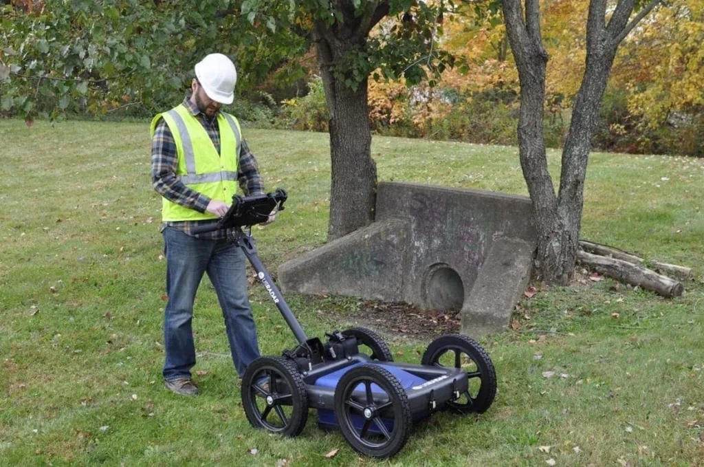
How GPR Technology Works
The system has an antenna that sends high-frequency waves into the earth. If these waves meet a change in material, some of the wave bounces back to another antenna that catches it.
actors like slab thickness, material type, and depth all shape how these waves act. The data gathered is turned into clear maps of what lies beneath the surface. These maps show where things are, their form, and how deep they are, like hidden structures, gaps, and other anomalies.
What’s Included in GPR Survey Services
When you engage professional GPR services, here’s what you can expect:
1. Site Assessment and Scan Planning
Before scanning begins, the technician will review the site, project needs, and potential risks. This includes identifying targets like utility lines, concrete structures, or underground storage tanks.
2. Field Scanning and Data Collection
Technicians perform a detailed site survey using portable or cart-mounted GPR equipment. Multiple passes are made to ensure coverage, and data is collected in real-time.
3. Data Processing and Analysis
The raw GPR data is converted into clean, readable formats. Advanced software identifies patterns in signal strength, depth, and material boundaries, helping professionals detect buried structures or embedded objects.
4. Reporting and Recommendations
The final report includes diagrams, scan maps, and annotations of any subsurface findings. Clear documentation supports decision-making around drilling, coring, or structural assessments.
What Can GPR Detect?
Ground penetrating radar services are highly effective at identifying:
- Underground utility lines – metallic, plastic, or fiber optic.
- Rebar, mesh, and post-tension cables in concrete.
- Changes in slab thickness or cracks in foundations.
- Void detection beneath pavements or slabs.
- Unmarked graves or geological features.
- Abandoned tanks or sewer systems.
- Embedded objects beneath the concrete surface.
Because GPR is responsive to contrast in electromagnetic properties, it can map targets with precision, even through reinforced or layered surfaces.
Applications Across Industries
Construction and Infrastructure
Before starting any build, GPR can identify where not to dig. Knowing the location of utilities, tanks, and concrete features supports safe planning, especially on complex construction projects.
Engineering and Architecture
For load-bearing analysis, GPR confirms the structural integrity of slabs, identifies post-tension cables, and evaluates embedded elements without destructive testing.
Environmental and Geotechnical
Geotechnical engineers use GPR survey services to understand soil makeup, locate voids, or assess fill quality beneath roads, bridges, or dams.
Utilities and Municipal
From underground utility mapping to sewer system checks, municipalities rely on GPR for maintenance, upgrades, and reducing disruption.
Forensics and Historical Preservation
Locating unmarked graves, preserving foundations, or documenting buried structures – GPR serves as a sensitive, respectful tool in archaeological and forensic work.
Key Benefits of GPR Services
Engaging GPR services provides advantages that other geophysical method options often can’t match:
- Non-destructive: No need for trenching or damaging the concrete surface.
- Efficient: Quick setup, scan, and data review.
- Precise: Detects materials at varying depths with high clarity.
- Safe: Supports ensuring safety by avoiding strikes or collapses.
- Cost-effective: Helps prevent delays and expensive rework.
These key benefits make GPR a vital part of pre-work assessments on both small and large-scale projects.
When Do You Need GPR Services?
Here are common scenarios where ground penetrating radar survey work is not just helpful, but critical.
- Before Coring or Drilling: Locating rebar, voids, or utilities avoids serious accidents.
- Renovating Concrete Structures: Determine slab thickness, scan for post-tension cables, and assess cracks.
- Installing New Utility Lines: Prevent collisions with existing utility lines.
- Evaluating Old Buildings or Roadbeds: Detect unknown buried structures or soil voids.
- Archaeological or Forensic Investigations: Preserve site integrity while identifying hidden features.
- Environmental Risk Mitigation: Map underground storage tanks, detect leaks, and support remediation.
In each case, GPR empowers users to take confident, informed decisions based on what’s actually below the surface.
What Can Affect the Accuracy of GPR Services?
While GPR services are highly adaptable, a few factors may limit effectiveness:
- Wet or clay-heavy soils may diminish resolution.
- Deep targets may require specialized antennas.
- Interpretation requires skilled analysts for accurate detection.
Still, in most scenarios, GPR delivers exceptional visibility when compared to traditional assessment methods.
Tips for Using GPR Effectively
To maximize value from your GPR scanning:
- Provide up-to-date site survey info to your provider.
- Clearly define scanning goals (e.g., “locate rebar,” “map voids”).
- Ensure the surface is accessible for consistent scanning.
- Ask for both raw and processed GPR data if further review is needed.
Collaboration between engineers, architects, and GPR technicians yields the best results, especially on large construction or remediation projects.
Final Thoughts
If you want to safeguard people, property, or performance, ground penetrating radar services let you see below the ground. By using GPR, teams across sectors gain access to fast, reliable, and actionable information without the cost and risk of breaking ground.
As the need for smarter site management, sustainable design, and low-impact surveying rises, GPR services are not just handy – they are essential.