Ground penetrating radar scanning gives you a clear look below the surface without digging or drilling. It helps locate underground utilities, detect underground storage tanks, and find subsurface contamination or hidden structural elements. It’s a simple yet powerful tool for construction projects, archaeology, environmental studies, engineering, and more.
This guide explains how ground penetrating radar works, when to use it, and what to expect from ground penetrating radar services. We explain ground penetrating radar theory, share best practices, and show what affects accuracy.
What Is Ground Penetrating Radar Scanning?
Ground penetrating radar (GPR) uses short bursts of radio waves or radar waves to detect subsurface objects. The system includes a transmitter antenna that emits an electromagnetic pulse. When these pulses hit materials with different electrical conductivity or relative permittivity, part bounces back as a reflected signal. A receiver antenna records this. The time delay of the reflection helps estimate depth, while signal strength aids in identifying the size and shape of the object. This interaction forms the basis of ground penetrating radar theory.
The collected GPR data or “radargrams” identify items like pipes, cables, voids, or buried tanks. With modern displays, you see a real-time image. After scans finish, technicians apply data processing and data interpretation. Results guide decisions on digging, construction, or cleanup.
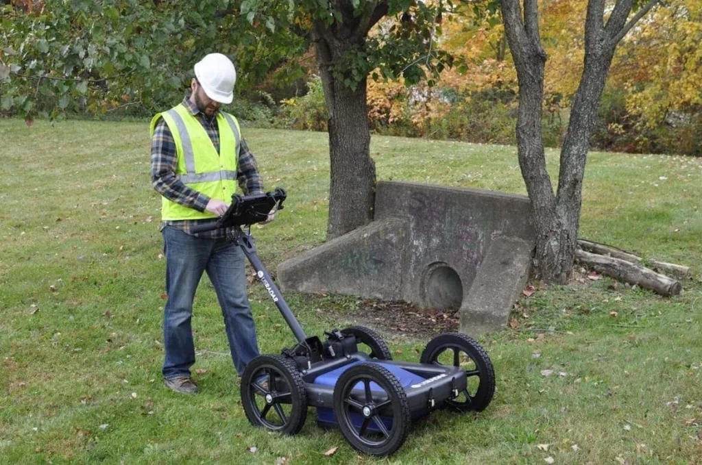
Key Components in a GPR System
A typical GPR system includes:
- GPR unit: The central housing for electronics and control.
- GPR antenna: Sends and receives radar pulses.
- Control unit: Let operators adjust settings, view real-time GPR data, and store scans.
- Display or storage: Shows results live or archives for later review.
- Mount: Sliders or carts help move over terrain. Drones or vehicles may carry units for wide-area scanning.
- Frequency options: Different frequency range alternatives to suit depth or resolution needs.
These parts work together. You adjust the GPR signal and frequency range to match your goal, like finding shallow utility lines or mapping deeper subsurface structures.
When Should You Use Ground Penetrating Radar Scanning?
You should consider ground penetrating radar scanning when you need safe, accurate subsurface insight without invasive methods:
- Utility locating before digging to avoid damaging buried lines.
- Locating underground storage tanks or buried objects.
- Concrete scanning to locate rebar, cables, or voids before drilling.
- Detecting subsurface anomalies, such as voids, sinkholes, or disturbed soil.
- Archaeologists work to identify unmarked graves or buried structures.
- Environmental surveys to spot subsurface contamination.
- Measuring ice thickness or frozen layers in polar research.
- Structural analysis of bridges, walls, or foundation slabs.
In each case, a GPR survey reduces risk, saves time, and gives a clear map of underground utilities and hidden features before moving dirt.
How GPR Works in Field Conditions
GPR scanning is straightforward:
- The operator sweeps the tool across the job site in straight lines or typical grid spacings.
- The radar pulses travel through the ground.
- When pulses encounter changes in dielectric permittivity or soil layers, they reflect.
- The returning GPR signal hits the receiver antenna.
- Software calculates depth using electromagnetic time-of-flight formulas.
- The output is a radargram that displays subsurface reflections by depth and location across the scan path.
Technicians often scan in multiple directions for full coverage. Combining GPR with methods like electromagnetic induction or resistivity strengthens results.
What Affects Ground Penetrating Radar Performance?
Effective GPR surveys depend on many factors:
- Soil conditions: Dry sand offers greater depth penetration. Wet clay or soil high in electrical conductivity weakens the signal.
- Frequency range: High frequencies (e.g., 900 MHz) provide sharp images but stay shallow. Low frequencies (e.g., 100 MHz) reach deeper but show less detail.
- Subsurface materials: Metals give a strong reflected signal. Plastics or materials similar to soil may produce weak reflections, making detection difficult.
- Electromagnetic properties: Factors like dielectric permittivity and relative permittivity affect how radar pulses reflect or transmit through subsurface layers.
- Signal attenuation: Moisture, roots, rocks, or nearby power lines can blur results.
- Equipment configuration: The GPR antenna choice, transmitter antenna power, and receiver antenna sensitivity all influence the quality and accuracy of the final GPR data.
Understanding these helps experts pick the right GPR method, tune the GPR unit, and measure subsurface features with pinpoint accuracy.
Common Applications of Ground Penetrating Radar Across Industries
Construction Projects
- Utility locating before trenching.
- Concrete scanning for rebar or post-tension cables.
- Bridge and foundation structural analysis.
Environmental & Geotechnical
- Spotting underground contamination.
- Surveying brownfields.
- Soil surveys in agriculture or civil engineering.
Archaeology & Heritage
- Finding unmarked graves.
- Mapping buried structures linked to heritage zones.
- Carrying out low-impact subsurface investigations before digs.
Forensics & Public Safety
- Recovering buried evidence.
- Searching graves or disaster zones.
Polar Research
- Measuring ice thickness and subsurface layering.
Data Collection & Interpretation
After scanning, you move to data interpretation:
- Load GPR data into the software.
- Use depth calculations to convert signal time to real-world measurements.
- Apply filters and migration correction to clean the image.
- Locate features by spotting consistent reflections or disruptions.
- Create depth profiles or maps from scans.
Following standards ensures reliable output. Combining GPR results with other geophysical techniques, like resistivity, strengthens findings. The goal: produce accurate data that supports confident decisions.
Performance Trade-Offs in Ground Penetrating Radar Applications
Advantages:
- Non-destructive and fast.
- Adjustable for range, scope, and depth.
- Real-time results speed up work.
- Ideal for urban or historic sites.
Limitations:
- Conductive soils limit penetrating radar effectiveness.
- Deep targets need lower frequencies, which reduce detail.
- Interpreting scans requires skill and training.
- Complex subsurface setups may require multiple methods.
Despite these challenges, GPR remains the best option for many jobs.
Choosing the Right GPR Services
Pick a provider that offers full ground penetrating radar services, including:
- Skilled operators.
- A modern GPR unit with varied frequency range antenna options.
- Rigorous quality control using typical grid spacings and repeat passes.
- Detailed data processing follow-through.
- Clear reports with radargrams, depth maps, and recommendations.
Work with providers versed in applied geophysics or geophysical methods, who know electromagnetic induction, resistivity, and GPR technology.
Summary: When to Use GPR & What to Expect
Choose ground penetrating radar scanning when you need clear subsurface insight without digging. It’s ideal for:
- Finding utility lines, tanks, cables, or buried objects.
- Mapping subsurface structures, voids, or hidden construction elements.
- Assessing contamination or archaeological interest.
- Checking the concrete before renovation.
- Scientific exploration, like ice thickness measurement.
GPR systems vary. Choose the correct frequency range, use proper electromagnetic energy, and interpret GPR data with care. Skilled operators with modern GPR equipment and solid data processing produce accurate data you can trust.
Final Thoughts
Ground penetrating radar scanning offers safe, efficient, and clear subsurface detection. It suits construction projects, environmental studies, historical digs, or forensic surveys. With the right GPR system, trained team, sound planning, and strong data interpretation, you can reveal what lies below. You’ll gain insights that build confidence, reduce risks, and improve results, without turning a spade of soil.