
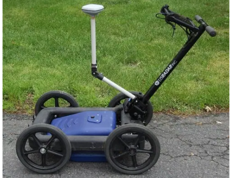
Q25 Geophysical Radar System
The Q25 geophysical radar system is a 250 MHz ground-penetrating radar designed for deep utility detection and geophysical applications. Operating in a lower frequency range optimized for penetration depth, the Q25 delivers clear imaging of subsurface anomalies across a wide variety of project needs. From locating buried utilities and mapping subsurface structures to supporting geophysical research, this GPR unit provides the depth performance professionals require in a rugged, field-ready package.
US Radar designed the Q25 with the same commitment to simplicity that defines every system in the product line. The self-calibrating antenna automatically adjusts to surrounding soil conditions, so operators can power on and start collecting GPR data within minutes. Whether you’re running a GPR survey for deep utility lines or investigating geological features across an open site, the Q25 puts reliable subsurface imaging in your hands without unnecessary complexity.
How the Q25 Works
Signal Transmission and Return
The Q25 ground-penetrating radar system transmits radar pulses of low-power electromagnetic energy into the ground surface through its transmitter antenna. As these radar waves travel through subsurface materials, they encounter boundaries between layers with different electromagnetic properties. When the GPR signal contacts buried objects, utility lines, or changes in dielectric properties, a portion of the energy reflects back toward the receiver antenna at the surface.
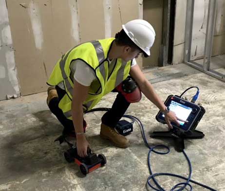
The receiver antenna captures these reflected signals and records the time and amplitude of each return. The Radar Acquisition Software processes raw data into clear, easy-to-understand subsurface images displayed in real time on the Getac tablet interface. You see what’s beneath the surface as you scan, with no waiting for post-processing before making field decisions.
250 MHz Frequency for Greater Penetration Depth
The Q25 operates at 250 MHz, a frequency range that provides the penetration depth needed for deep utility detection and geophysical investigation. Lower frequencies penetrate deeper into the subsurface, making the Q25 well-suited for projects where targets lie beyond the reach of higher frequency GPR equipment. Signal attenuation increases in areas with high electrical conductivity (such as wet clay soils), where GPR systems are generally limited to detecting near-surface disturbances. The Q25’s 250 MHz frequency balances depth performance with sufficient resolution for identifying subsurface features, buried utilities, and geological boundaries at moderate to deep depths.

Key Applications
- Deep Utility Detection and Locating – The Q25 excels at locating buried utilities that other geophysical methods may miss. Underground utilities made from non-metallic materials (including plastic pipes and fiber optic lines) are invisible to traditional electromagnetic methods, but GPR technology detects them based on differences in dielectric properties between the pipe and surrounding soil. The Q25’s 250 MHz antenna provides the depth needed for deep utility locating while maintaining resolution sufficient to distinguish individual targets.For construction projects where accurate subsurface information prevents costly utility strikes, the Q25 delivers reliable data in real time. The system’s automatic processing enables operators to identify utility lines and buried objects in the field without additional data processing steps.
- Geophysical Research and Investigation – Geophysical applications demand equipment capable of imaging subsurface structures at depth while maintaining data quality. The Q25 serves as an effective geophysical technique for mapping geological features, identifying subsurface anomalies, and documenting conditions across survey areas. The system’s data can be processed in Radar Studio for advanced data interpretation, depth slices, and visualization. Depth calibration capabilities allow operators to precisely calibrate velocity measurements, improving the accuracy of depth calculations across varying subsurface conditions.
- Tunnel Detection – Locating tunnels and underground voids requires a GPR system with sufficient penetration depth to reach targets well below the ground surface. The Q25’s lower frequency provides the depth performance needed to detect these large subsurface objects, producing clear radar signals that reveal voids, tunnels, and other significant anomalies. This capability makes the system valuable for civil engineering assessments and infrastructure planning.
Hardware Built for the Field
The Q25 ships as a complete, field-ready unit designed for the realities of daily survey work.
- Rugged Tablet Interface
The Getac tablet is daylight readable, weatherproof, and MIL-STD-810H certified for resistance to vibration, drops, and extreme temperatures. A high-performance CPU enables real-time data processing so you see subsurface images as you scan.
- Practical, Durable Design
The folding rough terrain cart stores compactly for transport between job sites. Airless, solid tires require no maintenance and eliminate the risk of punctures in harsh terrain. Military-grade connectors secure the connection between antenna and controller for reliable performance in demanding environments. Each battery pack provides up to 8 hours of continuous runtime, covering a full day of GPR survey work without interruption.
- Optional GPS Integration
The Q25 supports optional GPS integration for georeferenced survey data, enabling precision mapping and as-built documentation. The system works with external GPS receivers from handheld units to RTK rovers, tying subsurface findings to precise surface coordinates.
Software and Data Processing
Post-Processing and Export
For projects requiring advanced data processing, the optional Radar Studio software provides comprehensive post-processing capabilities. Transform raw GPR data into detailed visualizations with depth slices, annotation tools, and export functionality. All data exports to CAD files, Google Earth files, and other industry-standard formats. 3D imaging and modeling capabilities bring subsurface data to life, providing greater visual context for project stakeholders and collaborators. Data is also compatible with third-party software packages for integration with broader geophysical workflows.
Automatic Field Processing
The Q25 includes US Radar’s Radar Acquisition Software with autoconfiguration technology. After powering on, the antenna self-calibrates to the electromagnetic properties of the surrounding soil and subsurface materials. StreetSmart real-time processing displays findings as you scan, and SmartStack signal stacking with SmartGain2 automatically optimizes the GPR signal for current conditions. You spend less time adjusting system settings and more time collecting the data that matters.
Frequently Asked Questions
How deep can the Q25 see?
Penetration depth depends on both antenna frequency and site soil conditions. The Q25’s 250 MHz frequency is optimized for moderate to deep targets, making it well-suited for deep utility detection and geophysical investigation. In resistive soils (dry sand, gravel), radar signals travel deeper with less energy loss. In soils with high electrical conductivity (such as saturated clay), signal attenuation limits detection to near-surface disturbances. The system auto-calibrates to surrounding conditions when you power on, optimizing performance for whatever ground you’re working in.
Can the Q25 detect non-metallic utilities like plastic pipes?
Yes. GPR detects targets based on contrasts in dielectric properties between buried objects and surrounding soil, not based on whether the object conducts electricity. Plastic pipes, fiber optic cables, and PVC conduits all produce reflected signals that the Q25 images clearly. Many professionals pair GPR with electromagnetic locating to cover both metallic and non-metallic underground utilities across a site.
How quickly can my team start using the Q25?
The Q25 is designed so that your team can start collecting useful GPR data on day one. Power on the system, let the antenna auto-calibrate, and begin scanning. The Radar Acquisition Software processes data automatically and displays results in real time. For teams expanding into advanced workflows like GPS-integrated surveys or post-processing with Radar Studio, US Radar offers training resources delivered by a team with 60+ years of combined GPR experience.
What deliverable formats does the Q25 support?
The Radar Acquisition Software records all survey data digitally, creating permanent records you can share and revisit. With the optional Radar Studio software, you can generate depth slices, annotated cross-sections, and 3D models. Data exports to CAD files, Google Earth files, and formats compatible with major GIS and mapping platforms. GPS-integrated data ties findings to precise coordinates for professional as-built documentation.
Does the Q25 work in clay soils?
GPR systems can operate in wet clay soils but are generally limited to detecting near-surface disturbances in such environments. High electrical conductivity in saturated clay increases signal attenuation, reducing penetration depth. For challenging sites, contact our team for guidance on the best system and approach for your conditions.
How does the Q25 compare to US Radar's triple-frequency systems?
The Q25 is a single-frequency (250 MHz) system optimized for depth. US Radar’s triple frequency systems (the GPRover and Quantum Imager) emit three separate signals simultaneously, generating three independent datasets across low, mid, and high frequency ranges. If your projects require multi-depth imaging in a single pass with GPS mapping capabilities, a triple-frequency system may be the better fit. If your primary need is deeper penetration for geophysical targets or deep utilities, the Q25 delivers focused depth performance at 250 MHz. Not sure which fits best? Use our system selection guide or contact us for a recommendation.