
Understanding GPR Data: How Ground Penetrating Radar Works Beneath the Surface
Ground Penetrating Radar (GPR) has transformed the way we explore and understand what lies beneath the surface. GPR data is critical for utility locating and mapping, geophysical feature mapping, archaeology and grave site documentation, pipeline inspections and leak detection, and environmental studies. By emitting electromagnetic energy into the ground, GPR offers a non-invasive, high-resolution way to detect and visualize subsurface features. This guide will explore what GPR data is, how it’s collected and interpreted, and the many ways it is applied across industries. Whether you’re planning a construction project, need detailed subsurface utility locating, or are simply curious about how the technology works, this page will walk you through it all. A receiver antenna detects the reflected signal and creates a dataset—GPR records—that represent the position and shape of subsurface materials. These reflections help identify buried objects, voids, subsurface structures, and geological features. GPR data is essential for projects that require precise high resolution subsurface imagery. Its versatility and non-destructive testing technologies make it the method of choice in many geophysical techniques.
What Is GPR Data?
GPR data refers to the output generated by Ground Penetrating Radar systems. These systems send radar pulses—short bursts of electromagnetic energy—into the ground. As these waves pass through different materials, they reflect back at different rates depending on their electromagnetic properties. A receiver antenna detects the reflected signal and creates a dataset—GPR records—that represent the position and shape of subsurface materials. These reflections help identify buried objects, voids, subsurface structures, and geological features. GPR data is essential for projects that require precise high resolution subsurface imagery. Its versatility and non-destructive testing technologies make it the method of choice in many geophysical techniques.
Core Components of a GPR System
Understanding the structure of a GPR system is key to understanding how GPR data is collected:
Transmitter Antenna
This component generates the radar waves (electromagnetic pulses) and transmits them into the ground.
Receiver Antenna
Captures the reflected signal and converts it into readable data. The time it takes for the radar waves to return helps determine the depth of subsurface materials.
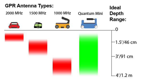
Antenna Frequency Range
A GPR system uses antennas with specific frequency ranges. Higher frequencies deliver more detailed imaging but shallower penetration, while lower frequencies provide deeper scans with less detail.
Data Processing Unit
This is the brain of the system. It stores and processes the incoming GPR data. The unit transforms raw signals into visuals that can be reviewed on-site or later with specialized software.
GPR Data Collection and Fieldwork
Planning a GPR Survey
Every successful GPR investigation starts with a well-planned GPR survey. Variables like soil composition, expected depth of targets, and environmental interference are all considered.
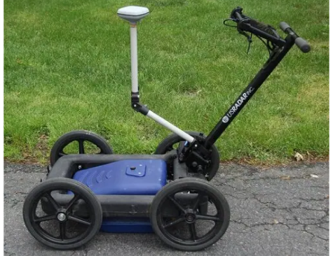
Running the GPR Unit
The GPR unit is moved systematically across the target area. Electromagnetic energy is sent into the ground, and reflected signals are recorded in real-time.
Environmental Factors
High electrical conductivity in soil, moisture levels, and temperature can impact GPR signal strength. Adjustments in antenna type or scan speed and the use of intuitive algorithms are helpful
Applied Geophysics Techniques
Combining the GPR method with other geophysical methods—like infrared thermography IR or electromagnetic induction—can improve the accuracy of data interpretation.
How GPR Data is Processed and Interpreted
Once data is collected, it goes through several steps of digital processing professional services:
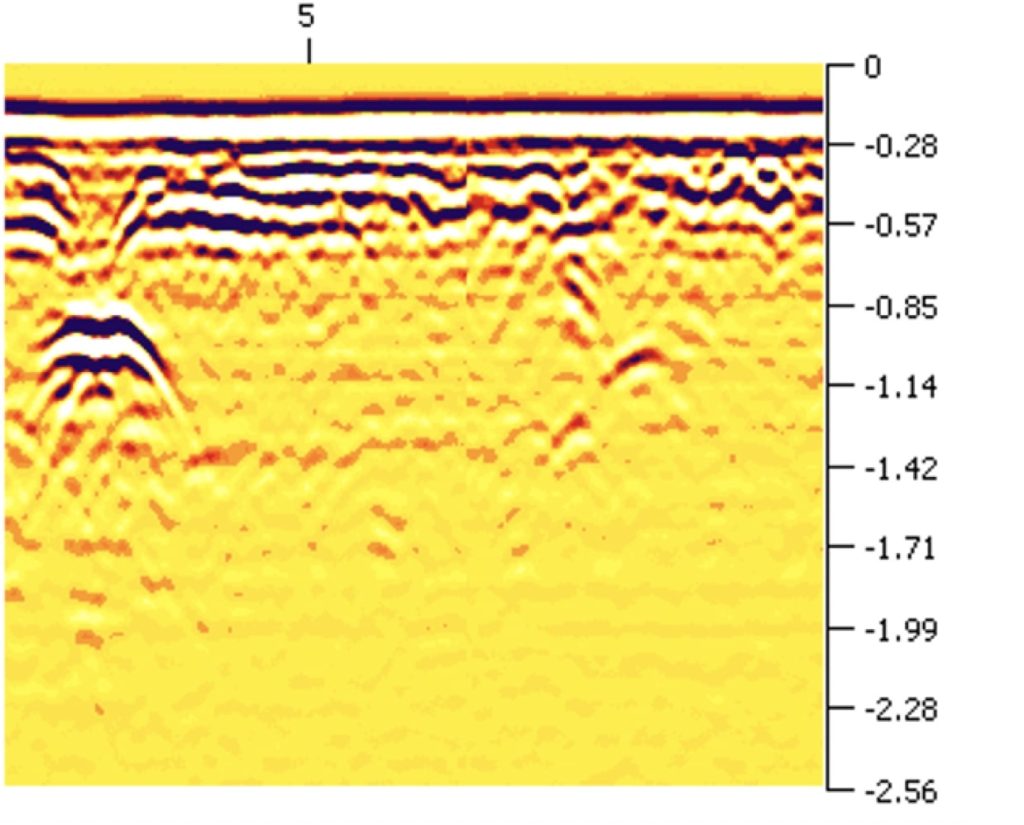
GPR Data Digital Processing
Modern systems offer cutting edge 3D GPR data digital modeling that can be reviewed in both 2D slices and full-resolution ground penetrating formats.
Data Interpretation
Operators interpret GPR data using intuitive software tools on-board the system. With a little bit of training, data interpretation becomes quite simple and even the novice can be interpreting data in no time.
Software Capabilities
Software now includes remote sensing overlays, drone aerial mapping integration, and video pipe inspection functionality. These innovations give ground penetrating radar experts a more complete picture.
Real-World Use Cases for GPR Data
GPR data is used across a wide variety of industries:
Construction
Avoid damage to buried utility lines using utility locating and mapping. Detect voids and ensure safe excavation.
Archaeology and Grave Site Mapping
Reveal historical remains and buried objects without disturbing sensitive locations.
Geology
Study soil layers, aquifers, and perform bedrock and boulder mapping with electromagnetic methods.
Environmental Science
Use GPR data to locate underground storage tanks, buried drums and other fill.
Infrastructure
GPR concrete imaging and bridge deck inspections provide engineers with a safe way to assess structural integrity.
Geophysical Studies
Bedrock and boulder mapping. Soil disturbances such as sinkhole evaluation. Changes in soil structure such as depth of overburden and limits of quarriable assets.
GPR Theory and Technological Advancements
Ground Penetrating Radar Theory
GPR works on the principle of detecting changes in dielectric permittivity between materials. These changes are captured via reflected signals and radar pulses.
Electromagnetic Pulse Propagation
An electromagnetic pulse travels through through the material under investigation until a change in values is detected, at which point a portion of the energy is reflected.
Why Frequency Range Matters
Different subsurface materials react uniquely to various frequency ranges. GPR systems come in a number of different frequency ranges enabling capabilities in various balancing resolutions. Choosing the right antenna(s) for the applications proposed is easy with the help of one of our staff.
Visualizing GPR Scans
Modern scanning delivers GPR scans with layered, high-definition imagery. When paired with GPS systems, the data can be geo-referenced for site plans.
Interpreting Subsurface Utility Locating Data
Subsurface utility locating is critical before any construction. GPR allows mapping without digging, ensuring safety and compliance with local regulations.

Wrapping Up: Why GPR Data is Indispensable
Understanding GPR data opens up powerful insights for any field that requires knowledge of the underground. Your project is supported by digital processing professional services, advanced equipment, and the expertise to interpret it correctly.
From grave site mapping to bridge deck inspections, trust in precise data, professional delivery, and smart decision-making supported by the latest in ground penetrating radar.